Circumnavigating Grande Terre: Touho to Heinghene

Anchor up in Touho at 0645 at sunup. We set the jib and reacher, but jib was by the lee so we furled the jib. Reacher only now, no engines, peaceful and quiet ride. Beautiful morning with rain showers out in the ocean to the northeast . Anchor down at Hienghene in 4M with 20M chain + bridle = 25M rode. Tide -0.4/+0.7. We dropped the hook smack on Splinter’s reported mark

The closest charted bit of the Les Tours Notre-Dame (la Poule) bears 29°M at .209nm. Nice sandy bottom, good holding. Wind is from about 75T ENE. Very nice anchorage except for N winds – completely open to the north. The black rocks along the coast and at the entrance to Hieghene are quite dramatic: tall columns and spires clustered together and worn into shapes like a nesting chicken, or the towers of Notre Dame, and on the other side of the entrance, the Sphynx. We watched a very small cruising sail boat come in and follow the red and green floating round buoys into the river and towards the tiny marina. We will take our dinghy there later. It was helpful to see how it is done. Clouds cover the entire sky, with bits of blue over the hills ashore. Wind is out of the SSW. This was not in the weather forecast. Baro has fallen 3 points since this morning. Sky has cleared half way. Today we visited Hienghene (pronounced “yen-gen”). The town seemed asleep, waiting for the cruise ship to come in, when they entertain the tourists. Even the pottery and wood carving sheds at the cultural center were closed. Hienghene is the birthplace of Jean-Marie Tjibaou, and the location of a cultural center that he organized.

Circumnavigating Grande Terre: Heinghene

Hienghene was the highlight of the east coast segment. The natural beauty of this area is stunning – perhaps that is why there is a BIG dock in the middle of town for landing the shuttle boats from a visiting cruise ship. Possibly because of the global financial crisis, there were no other visible tourists.

Hienghene is the home of Kanak hero/politician Jean-Marie Tjibaou – who of course is the man honored by the remarkable Tjibaou Culture Center. (our most recent visit to the center is described here).

A highlight of our time in Hienghene was exploring the Goa Ma Bwarhat Cultural Center which was also inspired by Jean-Marie Tjibaou. This center is a good source for understanding Kanak culture, and of the history of the political ferment that was the basis of Tjibaou’s popularity (and which led to his assassination 4 May 1989 in Ouvea).

The coastal maritime domain of Hienghene is considered to be the richest zone in marine biodiversity in New Caledonia. This region is on the World Heritage List, including a great diversity of coral forms, extensive marine turtle nesting sites, and breeding areas for threatened species such as dugongs, humpback whales and marine birds.

Circumnavigating Grande Terre: Lavaissiere to Touho

As we were departing Lavaissiere for Touho, we heard Noumea Radio loud and clear, for the first time since we had departed Yate. I hailed Noumea radio and received a response! I gave him our boat name and position “east of Baie de Canala”. I asked him for a weather report as we had not been able to receive Radio Noumea for the past three days. He said said that the wind forecast for the morning was ESE 15 knots.

We set the reacher and enjoyed beautiful, comfortable downwind sailing. We could see the white surf on the barrier reef 2.3 nautical miles away on our starboard side. Our next destination was the small harbor of Touho, ETA about 5 PM today. Beth and Bone on SPLINTERS APPRENTICE told us that this is a pleasant place to stop. As we approached the opening to Passe du Cap Bayes, we see that it is all clear with no reefs on our track. Every time I think I have sighted a ship with cranes on deck, it turns out to be an islet with pencil pines growing on it. We set our anchor in Touho Bay, outside and to the west of the little marina, not far from where SPLINTERS APPRENTICE anchored when they were here. It is a peaceful bay. Several small metal dinghies fishing in the bay. Entrance was easy, following the red and the green daymarks to avoid the reefs.

Circumnavigating Grande Terre: Yate to Lavaissere

From Yate’, we intended to sail to Canala, but after a brisk, downwind sail, we turned in to Lavaissere Bay. We decided to come into this bay because it was a shorter distance to the anchoring spot than in Canala Bay. We made it through the opening in the reef, which was about 1/4 mile wide, and then one of our engines died. We managed to get into the anchorage and set our anchor before the second engine died.

Whew! Dorothy got into the dinghy with a bridle off the stern and pulled ADAGIO away from the shore and its fringing reef, while Steve replaced the Racor fuel filter, refilled the day tank and bled the engines. The wind came from all points of the compass, turning us around and around. By sunset Steve had got the genset and port engine running, and had fixed the starboard engine before dark. The wind decreased at sunset. We took distance bearings on shore to monitor our position, as well as using the position on the electronic chart and GPS. We are anchored in the southeast corner of the bay. The other anchorages recommended in the cruising guide are even more windy than where we anchored.

We have marked this a DO NOT anchor spot on our charts!

Circumnavigating Grande Terre: Noumea to Yate

On 16-Sep we sailed out of Noumea — planning to enjoy Isle des Pins for a few days, then counter-clockwise around the “big island” Grande Terre. It was a beautiful day but with the winds strengthening from the south we anchored for the evening in Baie Ire — on the north side of Ile Ouen (on the south side of Canal Woodin). We shared the anchorage with a French Navy ship, as well as a New Zealand mega motor yacht. Setting sun was golden on the hills, with birds singing in the trees on shore.

The next morning we set off at dawn for Isle des Pins. We ran into just the sort of short, sharp head seas that tend to discourage a lot of cruisers from visiting our favorite part of New Caledonia. We sailed past Pass de la Havanna, then when we reached Pass Sarcelle we decided it was time to start that circumnavigation right now!

When we turned to the east in the pass we immediately picked up a 2 knot favorable current. Flocks of thousands of black shearwaters all around ADAGIO as we sail up the east side of Grand Terre, towards our first anchorage at Yate. Within an hour we had shifted from making 3.5kn south to making 8kn to the north.

In four hours we dropped the hook in Yate Bay on the southeast corner of the island of Grande Terre. This is a popular anchorage for boats rounding the island, and we were the only boat there. Yate is well protected and peaceful.

Ile des Pins to Noumea: Baie des Citrons

We had a fun sail from Kuto back to Noumea. Downwind under jib and reacher to start, whale watching boats, one Humpback fin flapping (BIG pectoral fin), lastly skilled kite-boarders at Anse Vata.

We’ve done the 70-odd nm trip between Noumea and Isle des Pins so many times we’ve lost count. But some days are very special — when we get wind going the way we want to go AND sunshine.

Sorry we didn’t get any pics of the Humpback whales. We were focused on whether we were going to commit to sailing into the reef pass on the SE of Ile Ouen into Port Koube for the night’s anchorage. We decided that was not prudent as the winds continued to build. So we enjoyed a very fine daysail all the way to Noumea.

3M Safety-Walk Tread: nonskid clear tape failed

For years we have enjoyed superb nonskid performance from the 3M Safety-Walk Tread. Until we tried the new 2″ clear version which we applied June 2009 before sailing back west across the Pacific from San Francisco. Just 10 weeks after painstakingly careful installation the new tape was failing – first the edges lift up, then the whole tape section peels off leaving just the adhesive. As always, click the thumbnail for the complete photo gallery.

UPDATE: by the time we made landfall in New Zealand some 90% of the new clear tape had fallen off. But the same 3M tape in grey we also applied to one hatch was still essentially perfect (also applied) in June 2009. Is this just a bad batch problem? Or is the clear version not suited to be used outdoors?

UPDATE: our adhesion problems were completely resolved by 3M New Zealand. See this March 2010 post for our experience of excellent 3M customer service.

4. Hawaii to New Caledonia — Landfall

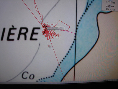
Aug 1, 2009 to Aug 15, 2009: landfall New Caledonia 0511 August 15th.

We lost our sailing breeze for the rest of the passage south of Tuvalu on August 7th. From here to New Caledonia we will be mostly motor-sailing on one engine, with intermittent teasers of 10 to 14kn wind speed where we set full main and reacher. The light conditions gave us time for more reading, more successful fishing and some very fine sunrises and sunsets.

On August 13 – 15 we logged the slowest passage speeds we’ve experienced so far (ranging from 2.5 to 3.3kn over the bottom). We are motor-sailing very slowly to delay our arrival in Havannah Pass to avoid the tide rips. As it turned out we needn’t have worried, but when the Pilot bold-faces their warnings to mariners we favor the cautious option.

August 8, 2009

1650 Set jib + full main. Can’t steer with pilot set to apparent wind angle because too unstable.

1849 #2 mainsail batten came loose 2-feet due to flogging in jerky sea light air. Dorothy restitched with help from Leo and George. Leo removed old stitching – the batten had pushed out above the velcro, so the stitching was not adequate to keep batten trapped by velcro. Also velcro is old and is not holding the batten in the way it should.

2137 Mainsail furled completely. Motoring only, no sail.

August 9, 2009

0100 Leo and I removed the main halyard from the sail because it was banging against the mast. Swell is still moving the boat around, making work a little tedious. Otherwise a pretty moon, puffy clouds, and only distant small squalls on the radar. A peaceful night, waiting for the trade winds to return. We seem to have a 1 kt favorable current.

0544 Set full main + jib. Moved Balmoral waypoint to leave it to port so we can sail free at AWA 48 deg.. Can take reef either side. Squalls at 20nm off port quarter.

0846 Freed sheets 20 degrees, to allow more W course. 143 nm in past 24 hrs, slowest day so far due to slow motoring in no wind.

1021 Furled the jib and set the reacher. ADAGIO is flying along now across bumpy seas. At this speed we will be at Havannah Pass on August 12. Breeze for sailing and for cooling the air temperature aboard. 718 nm to Havannah Pass. Now that the engines are off we will resume turning the genset on and off by one person going forward into the machinery space to connect and disconnect the wires.

1056 We altered course to AWA 90 deg. for better motion and to make the Balmoral Reef waypoint. Steve says since we do not have AWA, apparent wind on the reacher is OK as long as the TWD remains aft of the beam. Leo put out the fishing line.

1140 A fish took our lure and got off before we could reel him in. No gear lost this time.

1239 As I was doing the log we had a strike. Everyone is in the cockpit . I took Adagio to 130 deg. to slow the boat to reel in the fish. Over half an hour later a nice fat tuna was landed. Filleting and cleaning took another hour!

1327 Full main only until Dorothy finishes cleaning the tuna. Then back to reacher.

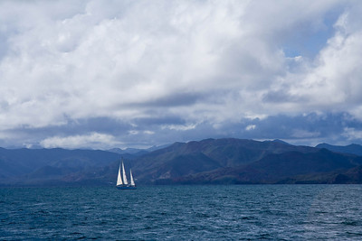
1411 Reacher reset. Bowling along at 9 knots in a pretty, smooth sea.

1921 Altered course to leave Balmoral shallow patch to starboard. Angles too tight, so started engine.

2054 We are heading west between the two Balmoral reefs, then will turn SW to our waypoint south of Vanuatu. At this rate we are due at Havannah Pass on Aug. 13, give or take. Sailing under full main and reacher. Moon has just appeared as a golden orb in the east, before being obscured by clouds on the horizon. Seas seem less boisterous than this afternoon.

August 10, 2009

0056 Altered waypoint to Aneityum Island.

0231 Plotted waypoint about where Rick forecasts cold front passage.

0256 Maybe 0.5kn gain in boat speed. Not much. Shook out first reef in the mainsail. Then first dialed up 20 deg COMPASS steering. Traveler was down 60%. Just kept luff tension tight.

0258 Two rain squalls off the starboard bow, 12nm ahead.

0258 Change pilot from COMPASS steering to to 80 deg apparent wind angle. I’m planning to sail a bit low of rhumb for better angles in light stuff after cold front.

0332 Still true wind speed varies 16-18 kts, lots of 11 knots of boat speed over the ground.

0614 AWA set to 90 deg when TWS 15 kts. Wind is now slowly backing which brings us closer to course. Dawn is beginning off to port. There is a sharp banging sound to stbd of the guest bed which keeps Penelope awake. It might be chain in the anchor locker that’s knocking about. Sky is more overcast than usual. A band of dark grey clouds ahead. We could be sailing into a weather system. Although the radar is clear.

1344 Stowed main. Battens 2 and 5 removed. They had escaped luff batten pockets. All batten pockets except top two are showing wear at luff. We gybed boom out to port end of traveler to give a clear line for the battens to be pulled out past the mast.

1530 Motoring in 5 knots of wind.

1641 510 nm to Havannah Pass: 3 days 12 hrs. Gentle swell with wind ripples. A booby bird circled ADAGIO for a while, but did not land. Sky more and more overcast. According to SatC weather forecast, we have crossed the axis of the first trough and are 320 nm from the second trough. The forecast rains and squally thunderstorms have not materialized. We are peacefully motoring again, reading, napping, visiting.

1944 Jib up close hauled. This added about 0.8 to 1.0 knots, enough to offset the windage speed loss.

2159 Stbd engine, slow down a bit to reduce wave-bashing. BIG difference between 5kn and 6kn into seas.

2345 Wind speed 19 to 21 kn ; direction fairly stable.

August 11, 2009

0212 Seas rough. We must be crossing the cold front that Rick mentioned in his update. Moon overhead. Radar clear. Wind speed is decreasing slowly and slightly. 459 nm to Havannah Pass.

0432 Great circus ride and hoorah no more anchor rolling. George has put a tournequet on the chains. Loosened lazy reacher sheet which is now lying quietly along the deck and not flogging. Penelope will sleep better now.

0810 Hoisted damaged main sail to second reef + jib, engine OFF, charge 92P. Fill daytank for accurate range.

1206 Careering south at 5+ knots boat speed in very bouncy seas. When ADAGIO lands after flying she judders just like a dog shakes after a swim.

1300 Put second reef in main with jib set. Rocking and rolling. T hinking of setting the reacher.

1330 Set reacher + main with second reef . The GFS model says wind will back to 106T until 0811 12Z.

1558 The ride is smoother and faster and closer to our course to Havannah Pass. It’s a beautiful day, cooler than yesterday. The Nadi weather forecast shows a trough in our vicinity bringing squally thunderstorms and scattered showers, but we are not seeing it out of our windows, only lovely fair weather cumulus and blue skies.

2251 Vessel sighted 4nm ahead bearing 231.

2320 Pilot error. I turned pilot off then on again, then re-set it to mode Wind. We are very slowly gaining on the boat ahead of us, tracking it on radar. I hailed it on the VHF radio and received no response. I got Steve out of bed. He set up the radar to better track the other boat. On the stabilized binoculars I see one white light, so we are seeing the stern light probably of another sail boat.

2349 Not enough wind to keep the autopilot happy, so I turned on the port engine to 1600 rpms and set the pilot to compass mode to 219 deg. Main and reacher are happier. Pilot happy. Radar was hung so I turned it off then on again. Autopilot on Compass mode keeps the other boat safely off to our stbd side, unless he changes course.

August 12, 2009

0243 White light disappeared over the horizon on our beam, so we are leaving the other boat behind. They seemed to be asleep. Clouds clearing, moon shining.

0732 Calm dawn; no sign of breeze.

0821 An overcast, moist morning with the sun trying to peek through the clouds astern. Wind is very slowly increasing. 281 nm to Havannah Pass.

0948 Engine Revs up to 2300 rpms. Now in the South Sub Tropical Current – setting us 1 kn to WNW. Steering 30 degrees higher to counter the current and get more south.

1211 It’s raining.

1304 Set reacher and full main.

1412 Wind backed 90-100 deg putting us on course for Australia. Furled reacher and main. Motoring.

1658 Land Ho!! Aneityum Island off the starboard bow, at 40 nm distant.

2157 Persistant rain.

2221 Port fresh water transfer pump running continiously. Turned off. No 1 Fresh Water pump functioning correctly. Check tank water levels and water pump every half hour for this watch.

August 13, 2009

0509 Steve has set the radar for us to use the A/C Auto button to suppress the rain clouds to better see other targets. Turned on No. 2 fresh water pump that Leo had turned off after turning off the water maker. Still raining. Clean boat. 177 nm, 1 day, 12 hours, to Havannah Pass at our current speed.

0702 As dawn broke the persistant rain took off. Sea is silky calm

0832 large container ship Pacific Destiny passing to port on recriproal course bearing 180 deg. 4 miles away, course 55deg. Sun appeared for a brief moment through leaden skies.

1302 Engine off. Sailing under full main and jib, beating towards the SE, in anticipation of a wind change so we can tack and make our course. George earned another gold medal for repairing the port side head. Fair weather cumulus clouds surround us. Dorothy phoned the marina on the island of Lifou to ask if ADAGIO would fit into their marina. Our plan would be to make landfall there, and have Steve fly to Noumea to check us in to customs and immigration. The answer was “Non”. ADAGIO is too large. So we are still heading towards Havannah Pass. We checked the tidal current tables on the chart which are referenced to Zhangjiang, China, to plan to arrive at the pass at slack low tide.

1502 Tacked towards Mare Island 66nm ahead in very bouncy seas, big swells off port bow in 15 kts true wind after sailing for 10 miles at right angles to our course away from destination. We are experiencing southwesterly winds in the SE trades.

1824 Sewing machine in action driven by Penelope converting French bicolour into a tricolour, whilst Adagio powers to windward.

2158 Slow progress in a rough sea. Southern Cross off port bow.

2259 Brightest stars ever! Persied meteor showers. Earlier this afternoon as we were reefing the main sail, batten number four popped out of the batten pocket at the luff. The pressure on the sail forces the batten forward of the luff and the feeder at the luff of the sail cuts through the batten pocket fabric. Leo and George came forward to help remove the batten from the pocket and stow it along side the dinghy. We can no longer reef the main down wind without losing battens. Steve turned the boat up into the wind to finish taking in the reef. We furled the jib after an hour’s bashing to windward to give us an easier ride. So we are motor sailing with two reefs in the main.

2338 Ship on radar off our port bow, range 13.4 nm bearing 188.9 deg M, course 223.7 M, speed 15.7 kts on a course parallel to ours. Quarter moon astern in rain-catch position. 98 nm to Havannah Pass, 31 hours.

August 14, 2009

0200 Moon atern, stars ahead.

0518 Our first view of New Caledonia is Mare Island, sighted on radar at 24 nm distant.

0615 Visual Land Ho! Mare Island, New Caledonia.

0832 Beautiful morning. Pity about the southerly wind direction. Slow progress in a lumpy sea.

1420 Land! Grande Terre sighted from 43 miles. By sunset, several peaks were in view.

August 15, 2009

0511 Landfall New Caledonia. We are 7.28 nm to our Havannah Pass waypoint. We have picked up the navigation light both visually and on the radar. ETA 1 hour 40 minuttes. Seas are calm. Quarter moon and stars. George and Leo took Steve’s watch. Stave stayed up last night to convert waypoints on our chart which is not chart datum WGS84.

1830 Arrive Noumea, New Caledonia, 3,623 nautical miles from Hawaii. As we approached Petite Rade, a nasty squall flattened the seas and reduced visibility. We had short tacked all the way from Canal Woodin to arrive before the official offices closed for the day. Sadly a loud “BANG” indicated that the bolt from the end of the boom had sheered so the main had to come down. It’s time we finished this amazing voyage. We berthed at the Visitor’s pontoon in Port de Moselle, most happy to have arrived safely and soundly, with all of our fingers and toes in tact, and all of our crew still on board, and still smiling.

We had traveled 3,623 nautical miles in 23 days, with an average of 156 nautical miles traveled per day.

Daily distances made good:


Day Date Time of Day Log Distance
1 7/23/09 1005 3739 175
2 7/24/09 1039 3914 196
3 7/25/09 1007 4110 225
4 7/26/09 1056 4335 192
5 7/27/09 1041 4527 203
6 7/28/09 959 4730 170
7 7/29/09 1036 4900 115
8 7/30/09 1020 5015 153
9 7/31/09 1038 5168 163
10 8/1/09 916 5331 217
11 8/2/09 1030 5548 194
12 8/3/09 924 5742 162
13 8/4/09 955 5904 177
14 8/5/09 1019 6081 171
8/6/09
15 8/7/09 923 6252 156
16 8/8/09 1021 6408 146
17 8/9/09 1021 6554 184
18 8/10/09 1022 6738 132
19 8/11/09 1010 6870 143
20 8/12/09 1022 7013 127
21 8/13/09 1030 7140 106
22 8/14/09 1132 7246 84
23 8/15/09 1030 7330 32
7362

3. Hawaii to New Caledonia — Best Sunrise, more booby pics

Aug 7, 2009:
… was August 7th, an easy pick. “Penelope and Dorothy were changing watches when the best sunrise of the passage occurred.”

2. Hawaii to New Caledonia — Crossing the Equator

Aug 1, 2009 to Aug 6, 2009:

To frame our evolving weather situation for this stage of the passage, here is Rick’s wx update received via Sailmail Sunday, July 26, 2009 3:18 AM

Hi Steve:

You are making great progress! There was an article about Adagio’s voyages in Latitude 38 daily electronic newsletter today. Very interesting. You have sailed a lot of miles.

Weather Summary:

1. As of 26 Jul 00Z

2. High pressure ridge dominates your weather until south of 10N. Winds continue to be ENEerly direction in the 20kt range.

3. On Jul 27th, direction backs to NEerly 20kts then abates to 15kts by Jul 28/2100Z. Approaching 10N, winds abate further to 10-13kts

4. ITCZ: Is active with deep convection, embedded thunderstorms and squalls between 160W to 170W. Downdraft winds in squalls have been measured by satellite to 40-50kts recently. Last record in the area between 165W to 170W and south of 10N indicated Eerly winds in rain at 20-25kts. The southern boundary of the ITCZ is near 02 30N where the winds veer to SEerly.

5. Route: You may want to avoid the area of deep convection between 160W to 170. Therefore suggest adjust to AP1 10N 175W. Then AP2 to 04N 175W. Crossing ITCZ may offer less chance of encountering the severest of squalls and thunderstorms. I realize this may put the apparent wind angle near 180deg. Therefore, suggest adjusting course as necessary for safe ride.

6. Forecast (to adjusted AP1 and AP2)

Date/Time UTC Wind kts Sig Wv ft

26Jul0600-28Jul1200 NE 18-23 5-7

28Jul1200-29Jul1800 NE 12-18 4-6

29Jul1800-31Jul1200 NE-SE 2-12 2-4

7. Sky conditions: Partly to mostly cloudy with isolated rainshowers to 10N. South of 10N, mostly cloudy with increased chances of squalls and thunderstorms.

We crossed the Equator today, August 1st, roughly the halfway point in our passage to New Caledonia. The equatorial weather doesn’t favor our original routing via Apia, Western Samoa. So we have elected for ‘Plan B’ which is Hawaii direct to New Caledonia.

Our course to avoid the ITCZ took us too far to the west for Apia to be a sensible stopover. We made it through the ITCZ with no dramas, having to motor for only one day. Now we are in the SE trade winds, and enjoying a brisk sail across benign seas beneath starry skies. It does not get better than this. Below are samples from our ship’s log for the second week of our voyaging.

August 1, 2009

0004 We are half way through our Gatorade instant mix powder which we turn into “Jungle Juice” over ice cubes. I made a banana cake yesterday and it is slowly disappearing. We estimate 10 days remaining to New Caledonia. We have plenty of food, but the fresh produce is running low. We’ll cross the Equator at about midnight tomorrow. We have one Pollywog aboard (George). The radar is clear; only a few wispy clouds in the sky which is filled with moonlight. We are looking forward to the full moon in a few days. Weather forecast is for more of the same wind and seas south of the Equator.

0352 Beautiful night quarter moon shining across the sea, wind and speed steady, sea down.

0618 Set reacher with 1st reef main – picked up 2.5kn at least and decreased AWS by 1 kn.

0853 Set full main. Headed a bit to around 96mag. Dorothy thinks yesterday’s rough seas may be due to the Equatorial counter current.

0916 Making good speed in moderate conditions.

1405 Boat spd between 8-10 kts under full main and reacher. Steve and Leo replaced the failed port water transfer pump (which also serves as an instant backup to our primary dual pressure water pumps).

1740 Changed B&G damping to 30 seconds on boat speed and TWS.

1952 Quiet period as we approach the Equator. Today is also our daughter’s birthday!

2207 We just crossed the Equator – George inducted to order of Shellbacks by King Neptune accompanied by a bottle of Charles Heidsieck champagne — which George & Penelope hand-carried halfway around the planet for this occasion.

2352 Wind wandering and the sea is flat and velvet with the moon shining.

August 2, 2009

0135 Course to steer (CTS) 216 degrees, leaving Winslow Reef to port. Steering AWA 60 deg watching actual course closely. Reacher trimmed about as tight as possible.

0617 We continue to make 9 kn over the bottom in 12 kn TWS. All night long ADAGIO has glided across benign seas, maintaining her course under an exceptionally brilliant stary sky. It does not get better than this!

August 2, 2009

0849 Glorious morning, sun shining, already over 80 deg F, seas calm, ADAGIO rushing along.
1030 Wind backing.

1147 Success to the fisherman: 7 lb Yellow Fin Tuna landed after repaired line had been set for less than 20 minutes.

1402 Reacher sheet leads reset to give clearance from deck.

1644 This is some of the most beautiful sailing ever, under full main and reacher, surrounded by puffy cumulus clouds. We lunched on tuna sashimi in a soy and ginger dipping sauce. We’ll poach the remainder of the fish in soy and mirin with sesame seeds and green onions for dinner. I put up our IKEA triangular awning over the cockpit for shade. It made a big difference on this hot afternoon.

2012 Twenty or more dolphins came swimming and leaping towards us from astern, and played in our bows for a while. Pacific White-sided dolphins we think.

August 3, 2009

0202 Moon almost full, ahead. Weather forecast for our course includes two Convergence Zones and two troughs. Seas are up a little so the ride is slightly bumpy. Otherwise, nothing has changed except for the veering wind. We turned the boat down to 120 AWA so that Leo could go forward to the machinery space and make the connection while Dorothy started the genset in the shop. Will check the genset every 30 minutes, while the batteries are charging. They started off at 59 percent at 0200 hours. This is the procedure that we follow to allow us to continue to use the genset in spite of a problem with it. Radar is clear. Sky is clear. Leo showed me that we are 16 nm above our course to the next waypoint, but not to worry at this time. We’ll make more easting in the morning.

0343 True wind speed has decreased and brought the boat speed down, but only temporarily.

0821 We furled the reacher and set the jib, and altered course to windward by 15 degrees. This will enable us to make back the easting that we had lost during the night as the wind veered. We have traded boat speed for distance. A beautiful morning, fair weather cumulus clouds all around, blue sky up above, seas are down. 356 nm to our waypoint near Funafuti.

0924 We are about 1,506 nm to Noumea, New Caledonia.

1158 Calm conditions; full main and jib. Making ground back to the rhumb line (near 20 miles).

1612 A ship appeared on the horizon bearing 250 deg and slow moving. Must be a fishing boat. He was on a parallel course and we passed him easily. Not visible on AIS. A few showers around us. Scattered cumulus. Jib and full main.

2227 Rolicking along under full main and jib. The radar is clear. Sitting out in the cockpit enjoying the show. Another beautiful evening, even better than yesterday, with the almost full moon lighting up the puffy small cumulus clouds and sparkling on the water.

August 4, 2009

0415 Before we switched to jib we were averaging a course of 212 deg. I sketched the 212 course back from Funafuti to estimate where we switch back to reacher at AWA 60.
0837 We furled the jib and unfurled the reacher, set the pilot to 70 AWA, and increased boat speed by two knots. A beautiful morning with blue skies and fair weather cumulus ahead and to port. A few showers astern but they should cross our wake. We are now to port of our rhumb line and headed straight for our waypoint, distant 212 nm, 22 hours sailing time estimated.

0955 Stbd reacher turning block post failed – missed Leo, hit Dorothy very hard in right arm above elbow – very big bruise, but no bone or tissue damage. Should have had a Dyneema safety rigged on that turning block.

1110 Steering direct for Aneityum waypoint. Reacher set again.
1404 Wind backed 20 deg and then veered back. Sailed at 70 deg to the wind for 30 minutes.

2053 Reeled in large Spanish mackerel who sadly got off the line as we were landing him and swam away.
2155 Enjoyed a quiet watch in the cockpit watching the stars with George.

August 5, 2009

0003 Ship sighted on radar at 9nm and on AIS bearing 166 deg, range 6, CPA 5nm in 10 minutes. Speed 10kn. Visual with binoculars at 5nm was intermittent in waves.
0036 Wind up to 15.5 knots; AWA down to 90 deg; still really slamming into waves.
0146 Wind lighter, up to 90 deg AWA. Rain squalls following us about 20nm aft of port quarter.
0405 Tuvalu to starboard. Tokelau to port. Samoa is 550 nm to the SE. Fiji is 180 nm to the south. Havannah Pass at New Caledonia is 1,155 nm to the SW. True wind speed is light at 10 kts. Sloppy seas so sails are flopping around. A few small squalls 6 nm astern. Almost full moon peeking through the clouds; comfortable air temperature. At this slow speed we will arrive at Havannah Pass on August 13. There is a small island 86 nm ahead called Nukulaelae.

0434 The little squalls have caught up with us from astern bringing increased wind speed and boat speed. TWD has backed 20 deg. I came down 10 deg. to 100 AWA.

0455 Wind backed to 33 deg TWA, now is veering. Rain — good, we needed a wash down. Radar shows a series of small cells following us. TWS backup to 20kts. Boat speed backup to 9 kts.

0504 Heavy rain. TWD now backed to 33 deg. TWS up to 22 knots, and now down to 16 kts. Boat speed up to 10 kts, now down to 8 kts. Squall is passing.

0511 TWD at 17 deg. Wind has backed a lot, so we are headed off to the SE. I hope it veers to its original direction.
0516 Squall has passed. Wind has died. Rain ended. TWD is still backing. Wind staying in the NNE.

1534 Pilot AWA to 70 to leave the island Nukulaelae to stbd. It is 18 nm ahead of us.

August 6, 2009

1800 Ships time changed to NZ time +1 day and 2 hours

2150 It is a beautiful evening with full moon and stars, clear skies, gentle breeze, and pleasant sail under full main and jib. We are winding our way through seamounts and atolls of the island group of Tuvalu.

Does it get even better!? You will have to read on….